
“GEGHARD”
SCIENTIFIC ANALYTICAL
FOUNDATION


2026
2026
2026-08-03
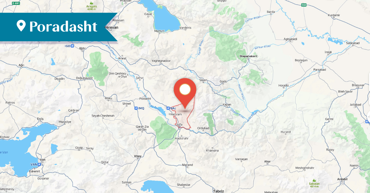
Poradasht was an Armenian village located in the Yernjak district of the Syunik province of Greater Armenia. It consisted of two settlements: Old Poradasht and New Poradasht. The village was situated northeast of the town of Jugha (Julfa), on the right bank of the Gilan river, on the slope of a high mountain range. It was also known by the alternative names Gajaran and Vochkharalearn.[1]
Old Poradasht (also referred to as Paradasht) is mentioned in sources as early as the Early Middle Ages, when it had an Armenian population of approximately 90–100 households. After the mid-sixteenth century, probably due to unfavorable local climatic conditions, the inhabitants relocated about one kilometer downhill and established a new settlement, New Poradasht.[2]
According to local legend, the name Poradasht derives from the presence of stones in the plain in front of the village that resembled coins (para in Armenian).[3] Between 1829 and 1832, the village had 15 households with a total Armenian population of about 81 people, including eight households that had migrated from Iran. According to the 1873 records, Poradasht comprised 40 households with 341 Armenian inhabitants.[4] As of 1914, the village remained entirely Armenian-populated.[5] The village's prominence was also noted by the Armenian scholar Ghevond Alishan.[6]
In the 1870s, an Armenian parish school was opened in the village. Despite periods of interruption, it operated until 1915, serving approximately 30–50 pupils.[7]
Today, the ruins of both the old and new village sites, along with several partially preserved historical and architectural monuments, still survive.
Old Poradasht was renowned for the Monastery of St. Stepanos, the church known as "Franki", and the Chapel of the Holy Mother of God.
The Monastery of St. Stepanos was located 4–5 km north of Old Poradasht. According to archival documents, the monastery was built by Archimandrite Malakhia in 1385.[8] According to local tradition, the monastery’s founder and patron was the renowned medieval Armenian scholar and philosopher Hovhan Vorotnetsi. The monastery was renovated in 1560 and 1683. Its entrance was located on the western façade, where inscriptions were also preserved. The monastery did not contain frescoes, sculptural representations, or ornamental carvings. In front of the western facade stood narthex, while 12–15 auxiliary structures were located on the southern and eastern sides. The monastery was also marked on a 1931 Soviet topographic map.[9] Satellite images indicate that, as of 7 October 2001, the ruins of the monastery were still standing; however, by 11 November 2009, they had been completely destroyed.[10]
North of Old Poradasht stood the church known as "Franki". One of the nearby khachkars (cross-stones) bore an inscription dated 1627. Today, the church lies in ruins.[11]
The Chapel of the Holy Mother of God, dated to the 16th–17th centuries, was located on the eastern side of Old Poradasht. It, too, is ruined.[12]
Approximately 0.5 km southeast of the old village site lies the village cemetery, dating from the 12th to the 17th centuries. The cemetery preserves approximately 580–600 flat and ram-shaped tombstones, as well as khachkars, of which 60–63 bear inscriptions. Most of the tombstones are broken and heavily weathered.[13]
Approximately 200–250 meters southeast of the Monastery of St. Stepanos lies the monastery cemetery, dating to the 16th–18th centuries. It contains six tombstones, five of which bear inscriptions. About 250–300 meters east of the monastery, between two massive rock formations, is the sacred spring-shrine known as "Nahatak" ("Martyr"). The shrine was restored in the 17th century. Several partially ruined khachkars dating from the 15th–17th centuries are located in the surrounding area. Today, the spring remains preserved, while the chapel is in ruins.[14]
By the 1950s, Old Poradasht had been depopulated of its Armenian inhabitants and had become an abandoned village in ruins.[15]
New Poradasht was located approximately 1 km south of Old Poradasht. It comprised 130–140 residential houses and other buildings. The village was known for the Church of St. Gevorg, the Chapel of St. Elijah (St. Yeghia), and several other historical monuments. The Church of St. Gevorg was situated in the western part of the village and was designed by the architect Hovhan.[16] It was a timber-roofed structure enclosed by high and spacious walls. A khachkar in the churchyard bears a 1683 inscription mentioning its maker, Master Daniel.[17] The church entrance was located on the western facade. It contained no frescoes, sculptural representations, or ornamental carvings. The church was renovated in the 19th century.
In the 1950s, the church building was converted into a school. Between 1964 and 1987, it fell into a state of severe neglect. Its wooden roof, southern wall, and sacristy were destroyed. According to satellite imagery, the church's foundations were still visible as of 7 October 2001. However, by 11 November 2009, the remaining ruins had been completely demolished, and the site had been leveled. [18]
On a prominent hill west of New Poradasht stood the Surb Yeghia Chapel, built in the 17th century. The chapel bore neither inscriptions nor sculptural reliefs. Several 17th-century Armenian cross-stones have been preserved in its vicinity. Today, the chapel is in ruined condition.
The village cemetery, located in the eastern part of the settlement, dates from the 17th to the 20th centuries. It contains approximately 500–510 rectangular and ram-shaped tombstones, of which 250–255 bear inscriptions.[19]
Poradasht was the birthplace of the distinguished Armenian philologist, historian, geographer, and ecclesiastical figure Archbishop Mesrop Smbatyants.
Today, the historic village of Poradasht lies in ruins and is uninhabited. It is situated in the Julfa (Jugha) District of the Nakhijevan Autonomous Republic, approximately 25 km northeast of the town of Julfa.
Bibliography
Ghevond Alishan, Sisakan, Venice, 1893.
Dictionary of Toponyms of Armenia and Adjacent Regions, Vol. 5, list 1, Yerevan, 2001.
St. Melik-Bakhshyan. Armenian Places of Worship. Yerevan State University Press, Yerevan, 2009.
A. Ayvazyan, The Armenian Monuments of the Nakhijevan ASSR: A Comprehensive List, Yerevan, 1986․
A. Ayvazyan, The Monumental Memorials and Relief Carvings of Nakhijevan, Yerevan, 1987.
Caucasus Heritage Watch. Surb Stepanos Monastery of Old Poradasht. https://storymaps.arcgis.com/stories/e275d2e351d6410aaf3add87c6e3235b
Nakhijevan Atlas, Research on Armenian Architecture Foundation, Yerevan, 2012․
[1] Dictionary of Toponyms of Armenia and Adjacent Regions, Vol. 5, list 1, Yerevan, 2001, pp. 241-242։
[2] A. Ayvazyan, The Monumental Memorials and Relief Carvings of Nakhijevan, Yerevan, 1987, p. 77.
[3] Dictionary of Toponyms of Armenia and Adjacent Regions, Vol. 5, list 1, Yerevan, 2001, pp. 241-242.
[4] Ibid.
[5] Nakhijevan Atlas, Yerevan, 2012, p 21.
[6] Ghevond Alishan, Sisakan, Venice, 1893, p. 359.
[7] Dictionary of Toponyms of Armenia and Adjacent Regions, Vol. 5, list 1, Yerevan, 2001, pp. 241-242.
[8] St. Melik-Bakhshyan. Armenian Places of Worship. Yerevan State University Press, Yerevan, 2009, pp. 378-379.
[9] Caucasus Heritage Watch. Surb Stepanos Monastery of Old Poradasht. https://storymaps.arcgis.com/stories/e275d2e351d6410aaf3add87c6e3235b.
[10] Ibid.
[11] St. Melik-Bakhshyan, p. 427.
[12] Nakhijevan Atlas, Yerevan, 2012, p. 24.
[13] A. Ayvazyan, The Armenian Monuments of the Nakhijevan ASSR: A Comprehensive List, Yerevan, 1986, p. 84.
[14] Ibid. pp. 84-85.
[15] Caucasus Heritage Watch. Surb Stepanos Monastery of Old Poradasht. https://storymaps.arcgis.com/stories/e275d2e351d6410aaf3add87c6e3235b.
[16] A. Ayvazyan, The Armenian Monuments of the Nakhijevan ASSR: A Comprehensive List, Yerevan, 1986, p. 82։
[17] St. Melik-Bakhshyan, p. 103.
[18] Caucasus Heritage Watch. Surb Stepanos Monastery of Old Poradasht. https://storymaps.arcgis.com/stories/e275d2e351d6410aaf3add87c6e3235b.
[19] A. Ayvazyan, The Armenian Monuments of the Nakhijevan ASSR: A Comprehensive List, Yerevan, 1986, p. 83։