“GEGHARD”
SCIENTIFIC ANALYTICAL
FOUNDATION


2026
2026
2025-07-17
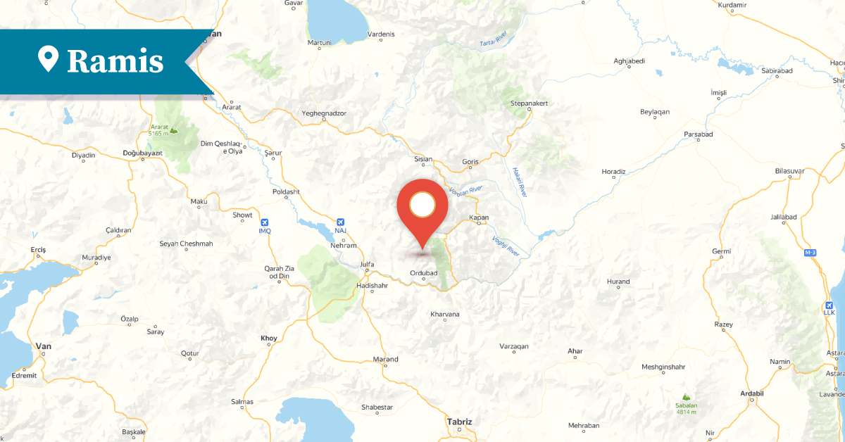
Ramis was one of the picturesque Armenian villages of the Goghtn (Goghtan) district.[1] The village was also known by various other names such as Ramik, Rumis, Urumis, Urtsmis, and Urimis. Geographically, Ramis was located in the highland zone of Mountainous Goghtn, within the Zangezur mountain range, at an elevation of 2,600–2,800 meters above sea level.
According to Ghevond Alishan and Yervand Lalayan, Ramis is mentioned in a 17th-century rock inscription on the western façade of the Saint Thomas (Surb Tovma) Monastery of Agulis, listed among the villages and settlements of the Goghtn district.
Bartholomew came to Armenia,
First founded the Lord’s house here
And named it after Saint Thomas the Apostle.
He appointed his disciple, named Komes,
As bishop there.
And entrusted him with the Goghtn district
As his chosen flock.
He praised the village of Dasht near Agulis
And entrusted him with Tsghna and Ramis;
He also gave him Bust and Paraka. [2]
Ramis is mentioned in the 18th-century chronicle by vardapet Isahak, where it is noted that it was written in 1695 at the Monastery of Saint Thaddeus, “at the request Anush a lord from Ramis.”[3]
According to records from 1829, Ramis had 55 Armenian households. In 1873, the number had grown to 377 households. In 1907, the village remained entirely Armenian, with 335 households. By 1914, the population was still exclusively Armenian, but by 1940, it had decreased to 70 Armenian families.
The ruins of Ramis and its surrounding areas testify that the settlement was founded in very ancient times. During the Middle Ages, the village was quite developed, as evidenced by the remains of various monuments, churches, chapels, sacred sites, fortresses, mills, and an extensive cemetery. The latter was located in the northeastern part of the village and dated from the 14th to the 19th centuries. The cemetery contained over 600 tombstones and numerous khachkars (cross-stones), 124 of which bore inscriptions, although many were eroded and difficult to read. The 1974 Soviet topographic map documented the Ramis cemetery. Satellite images confirm that the cemetery was destroyed in 2009. Traces of several chapels, mills, and fortresses are still visible in the ruins of the village and its surroundings.
The most prominent monument of Ramis was the Church of the Holy Mother of God (Surb Astvatsatsin), located in the elevated district of the village. It is mentioned by Ghevond Alishan and Yervand Lalayan. Numerous rock-carved inscriptions were preserved on the church walls. The Church of the Holy Mother of God was originally built in the 12th century and was renovated in 1677–78. According to a preserved inscription, the renovator-architect was “Master Murad.” The church was rich in relief sculptures and frescoes. As of the 1980s, the church was still standing, but it was completely destroyed by Azerbaijani authorities between 2000 and 2009.
In the historic cemetery of the Church of the Holy Mother of God in Ramis, there were 16 tombstones, 12 of which bore preserved Armenian inscriptions documented by historian Argam Ayvazyan.
In the center of the village stood the Church of Saint Hovhannes (Saint Hakob), built in the medieval period and mentioned in 1840. It now lies in ruins.
About 5 kilometers south of the village, the semi-ruined Church of Saint Sargis can still be found, which was mentioned in the 1890s.
On an elevated site in the northwestern quarter of Ramis, the remains of the chapel of Saint Karapet have been preserved. No Muslim monuments existed in the village.
In the late medieval period, Ramis was also a center of manuscript production, where a manuscript dated to 1604 was copied. In 1890, an Armenian parochial school was established in the village.
In the summer of 1919, the village came under attack by Turkish-Tatar forces. Along with the residents of five other Armenian villages in Mountainous Goghtn—Bist, Tsghna, Nasrvaz, Paraka, and Alahi—the Armenian population of Ramis resisted enemy assaults for several months. The last seven Armenian households of Ramis were displaced in 1989.
Today, the village is located in the Ordubad district of the Nakhijevan Autonomous Republic, about 20 km northwest of the town of Ordubad, and is in ruins.
Bibliography
Ghevond Alishan, Sisakan, Venice, 1893.
Journey of Deacon of Holy Etchmiadzin Mesrop Taghiadiants, M. A., to Armenia Calcutta, 1847.
Yervand Lalayan, Nakhijevan Province, Book XI 1904.
T. Kh. Hakobyan, St. T. Melik-Bakhshyan, H. Kh. Barseghyan, Dictionary of Toponyms of Armenia and Adjacent Regions, Vol. 4, Yerevan, 1998.
A. Ayvazyan, Nakhijevan: An Illustrated Encyclopedic Guide, Yerevan, 1995.
А. Ayvazyan, The Armenian Monuments of the Nakhijevan ASSR: A Comprehensive List. Yerevan, 1986.
A. Ayvazyan, “The Three-Nave Basilica of Ramis and Its Inscriptions.” Historical-Philological Journal, no. 3 (1979).
Nakhijevan Atlas, Research on Armenian Architecture Foundation, Yerevan, 2012.
E. Zohrabyan, The Nakhijevan Issue and Armenia’s “Allies” (December 1918 – April 1920). Yerevan, 2002.
Minor Chronicles of the 13th–18th Centuries, Vol. 1. Materials for the History of the Armenian People, Book 3. Compiled by V. A. Hakobyan. Institute of History, Academy of Sciences of the Armenian SSR. Yerevan, 1951.
[1] Ramis — Azerbaijani: Urmis.
[2] Gh. Alishan, Sisakan, Goghtn, Venice, 1893, p. 326.
[3] Minor Chronicles of the 13th–18th Centuries, Vol. 1., Yerevan, 1951, pp. 297-298.